Back to
Results
For those
who would like to know how they did.
We hope
you enjoyed rallying in scenic Lebanon
and Tewksbury townships.
You passed many, many farms.
Except for Leg 1, the different legs of the rallye were named after farms that
were seen either on- or off-course.
It did not impact mileage.
Leg 1 –
From Instruction 1 to Instruction 7
Official mileage: 4.68 miles
This is a
self-correcting trap.
Instruction
2 directed you to go R FOPP.
In previous Teddy Bear rallyes, we sometimes stated that Route 46 was a
forced R out of the Subaru 46 dealership and many times the next instruction was
L at SIG (instead of simply L FOPP as directed in instruction 3).
You still have to leave the dealership to start and the only way to do
this is a forced R out of the parking lot onto Route 46 West (as you can not go
L onto Route 46 East). After you
did your forced R, which does not require an instruction, you should have made
your first R opportunity on Harris Lane (which
comes up quickly). You would then
have made a L on Sand Shore Road,
where you would have encountered a manned on-course Passage Control.
You would then have proceeded straight as possible through the SIG and
joined up with the other rallyists looking to execute instruction 4; R at SOL
“MISSION RD”.
Penalty:
17
mileage points (under mileage), plus NOT stopping at an on-course Passage
Control (200 points)
Leg 2 –
From Instruction 8 to Instruction 14 Official
mileage: 5.48 miles
Instruction 13
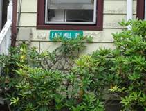
directed you to go R second OPP after “EAST MILL RD”.
Per the general instructions, this was a sign that was referenced
directly (all caps and in quotes), so you needed to find a sign that said this
exactly. The first EAST MILL RD sign
that you should have found is an actual street sign, but is mounted on the front
of a house that was prior to the shopping mall (see page 2).
The street after this house would be the
first on-course OPP. The second OPP
is Old Farmers Rd, which you should have turned on.
You then would have seen the Post Office mailboxes in
Photo A.
If you did not see the sign on the house, the next
EAST MILL RD
sign is on the near side of Old
Farmers Rd.
For those off-course, Old Farmers Rd would have been your first OPP, and
you would have continued on Route 513 until
East Valley Brook Rd, which would have been your
second OPP. If you went past East Valley Brook Rd, you would have seen
East Gate Rd,
which was too far. Everyone is then
joined up and looking for the at STOP at Fairmount checkpoint.
Penalty:
227
mileage points (over mileage)
Leg 3 –
From Instruction 15 to Instruction 22
Official mileage: 10.74
miles
This is a
self-correcting trap.
Instruction 18 directed you
to go R FOPP, TTU.
According to the general rules, the rallye is on through, paved, public roads.
Roads other than these do not exist unless the factor that makes them
nonexistent is specifically overridden in the route instructions.
In instruction 18, you turned right on
Pickle Road, which eventually becomes
unpaved.
You were not directed onto Pickle Road by name.
You then continued on Pickle Road where you came to an
intersection where the road on the right
–
Van Pelt Road
–
is paved.
As Van Pelt Road
is paved, this is a forced right turn (earlier,
Pickle Road
became paved then unpaved, but since there was no intersection, per the general
instructions, you had to go S as possible).
If you stayed straight on the unpaved Pickle Road, you would have executed R at
STOP onto Route 512 West and joined the others who also made a R at STOP onto
Route 512 West.
Penalty:
122
mileage points (over mileage)
Leg 4 –
From Instruction 23 to Instruction 27
Official mileage: 3.81 miles
This is a
self-correcting trap.
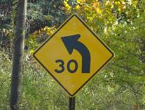
Instruction 25 directed you
to go L after second “SPEED LIMIT 30”.
After you went over the green bridge, you came to an intersection with a
“SPEED LIMIT 30” sign directly ahead of you.
There was also one to your right within 90 degrees of sight on Rockaway Rd (see page 2).
Once through the intersection, you would have passed this second “SPEED
LIMIT 30” sign and should have looked to make your L onto
Lance Rd.
If you did not see or count the SPEED LIMIT 30 sign on your right, you
would have continued and eventually made a L onto Halls Mill Road
after seeing another SPEED LIMIT 30 sign (you would have passed another SPEED
LIMIT 30 sign, but that did not matter). Everyone
would have then made a L on Taylors Mill Road
and joined up again to look for the
“SOL “TRIMMER RD” checkpoint.
Penalty:
172
mileage points (over mileage)
Leg 5 –
From Instruction 28 to Instruction 32
Official mileage: 5.61 miles
This is a
self-correcting trap.
Instruction 30 directed you
to go R FOPP.
Meadow Lane is an unpaved road within sight, so it is not a valid OPP and
should not have been turned on. You
should have continued past Meadow
Land
and Alpaugh Farm Road
(a dead end) and then turned R at the first OPP, which was Still Hollow Rd.
Everyone would have made a L at STOP on Rockaway Rd and
joined up again looking for the “STOP” at STOP checkpoint in the village of Mountainville.
Penalty:
124
mileage points (under mileage)
Leg 6 –
From Instruction 33 to Instruction 36
Official mileage: 5.48 miles
This is a
self-correcting trap.
Instruction 34
directed
you to R after “GUINEA HOLLOW RD”.
The delta mileage for this instruction
was 2.0 miles. Sutton Rd is the first OPP, but it is only
1.7 miles, not 2.0 miles, therefore you should not have turned onto Sutton Road, but
instead gone just a little further and made a R on Route 512.
Everyone would have made a R on Farmersville Rd and
joined up again to look for the “STOP” at STOP checkpoint.
As for Photo B, we needed a
sixth photo so included this nice sculpture from the West Rutland Art Park in
Vermont
(https:
//www.westrutlandartpark.com/).
Penalty:
53
mileage points (under mileage)
Leg 7 –
From Instruction 37 to Instruction 40
Official mileage: 6.97 miles
This is a
self-correcting trap.
Instruction 38 directed you
to L onto Homestead Rd.
As you were directed onto
Homestead Rd
by name, you should have looked for signs to stay onto Homestead Rd (but
might have been reading about the farm).
At the first intersection, you should have turned R to stay onto Homestead Rd.
Those that went straight, ended up on Cold Spring Rd
instead and would have seen the scene in Photo C and then made a R at
T. Everyone would have made a L at
STOP on Hollow Brook Rd and
joined up again to look for the “STOP” at STOP checkpoint.
Penalty:
166
mileage points (under mileage)
Leg 8 –
From Instruction 41 to Instruction 46
Official mileage: 8.44 miles
ODOMETER LEG
This is the official odometer
leg.
There were no planned traps in this leg.
SOL Photo D was on-course,
and just very cool.
Leg 9 –
From Instruction 47 to Instruction 54
Official mileage: 7.26 miles
After Instruction 53, you were looking for the
HTS SOL scene in
Photo E.
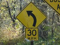
Instruction 53 directed you
to L FOPP after RIP “30”.
The first sign you encounter on
Sliker Rd
after you had executed Instruction 52, was a sign that just has an arrow and a
30. This is not RIP, which
according to the generals, is only used when a sign is not quoted in its
entirety, and is not used because of illustrations on the sign.
Those of you that considered this RIP would have turned L FOPP on Teetertown Rd where
you would have seen the HTS SOL Goatland sign in Photo E, then BR at the Y onto
Maple Ln,
then L at STOP to join the others on Route 513.
Everyone else continued down
Sliker Rd where they would have encountered a sign
that said “30 M.P.H.” which is RIP “30” (see below).
They would have made the L FOPP onto Route 513, and then everyone would
have joined up and pulled off on the shoulder at RIP “BARKMAN” for the
checkpoint. Small mileage; but a
different kind of sign.
Penalty:
12
mileage points (over mileage)
Leg 10 –
From Instruction 55 to Instruction 58
Official mileage: 8.62 miles
This is a
self-correcting trap.
Instruction 55 directed you
to go R at SOL
Blue
Crest Riding
Center, then PU Beacon Light
Rd.
You were then looking for the
Photo F scene after finishing Instruction 55.
When you PU, you are to go essentially
straight onto a named or numbered road at the identifying sign.
Beacon Hill Rd turns into
Beacon Light Rd after you see
the Photo F scene (there is a street sign on the right at Terrill Rd that lets
you know that Beacon Hill Rd is now
Beacon Light Rd).
You need to complete instruction 55 before executing the Photo F
instruction. If you did not
complete instruction 55 and executed the Photo F instruction of L at STOP onto
W. Valley Brook Rd, you would have eventually
executed instruction 56; L at STOP (onto Fairmount Rd).
Those that eventually did PU Beacon Light Rd
also made a L at STOP (onto
Fairmount Rd).
Everyone then joins up and makes a left into the SOL parking lot of the
Long Valley Brew Pub.
Penalty:
154
mileage points (under mileage)
Leg
2
– “EAST MILL RD”
Leg 4 – First “SPEED
LIMIT 30”
Leg 9 – RIP “30”
(incorrect and correct)


Total overall official mileage for today’s rallye was 67.09 miles.
As always, the real winners of today’s rally are the recipients of the
toys that were donated for the USMC”TOYS FOR TOTS” program.
We hope you enjoyed the event and look forward to seeing you next
December for the running of the 25thTeddy Bear Rallye!
Thank you!